
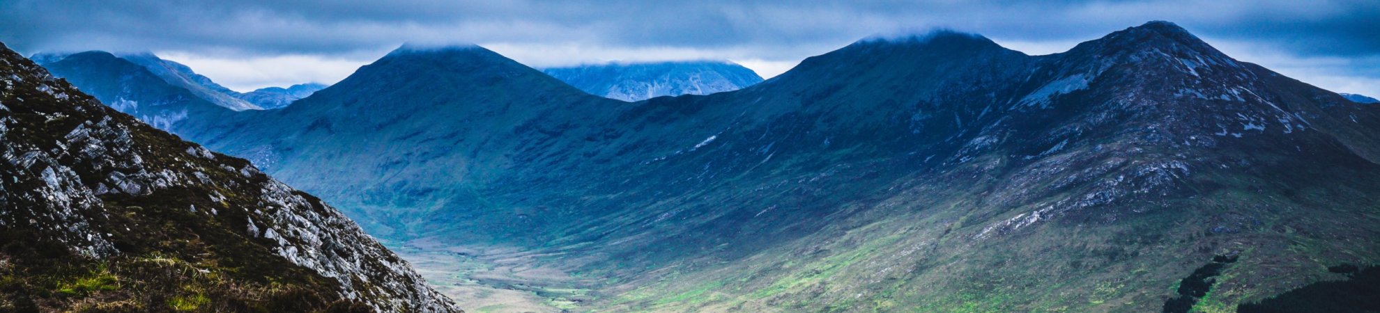
Fancy something lung-bursting? We may not have the highest peaks in the world, but we still have some beauties. Try one Ireland’s best mountain walks.
Ireland doesn’t have mountains on par with Everest or Kilimanjaro but what we do have is an abundance of punchy little peaks up and down the country. And we promise they will take your breath away, make you gape in awe and all without the risk of altitude sickness or falling through a crevasse. Here are six of our favourite mountain walks in Ireland.
1. Croagh Patrick, Co Mayo
Height: 764m
Ordnance Survey Maps: 30 & 37
Sitting just outside Westport is Croagh Patrick, arguably our most well-known peak. Made famous by our patron saint St. Patrick for fasting on the top of the mountain for 40 days and 40 nights. It’s a tough drag up the side of the conical tower over uneven rocks and loose scree. But you will be rewarded with incredible panoramic views of the hundreds of tiny drumlin islands in Clew Bay and the very best of the Wild Atlantic Way. Catch your breath at mass in the gem of a church that sits on the summit.
The hike will take about three or four hours to get up and back down, on what is a 14km round trip. You don’t need to know how to navigate just follow the people, which is ironically the only downfall of this climb, during the high season it’s busy!
Check out our full review of Croagh Patrick for more information.
2. Mt Leinster, Co Wexford
Height: 793m
Ordnance Survey Map: 68
Standing on the summit of Mt. Leinster, you will revel in the biting winds, beautiful views of the patchwork green fields of the valley below and the semi-wild horses and sheep grazing on its pastures. The mountain overlooks the three counties of Carlow, Wexford and Wicklow and there are plenty of walks to choose from.
The Blackstairs Challenge walk is a 30km undertaking that traverses the entire range. But perhaps the most accessible option is to drive to the gap at the Nine Stones and to make the 6km round trip to the summit via the access road. Although be warned, the nine stones themselves are very unimpressive! There are also some great mountain bike trails in the forestry carved by the local club Racing795 if you are so inclined.
Check out our full review of Mt Leinster for more information.
3. Slieve Donard, Co Down
Height: 850m
Ordnance Survey Map: 29
Slieve Donard is Northern Ireland’s highest peak and stands at 850m. It is part of the enchanting Mourne Mountain range. A 9.2km round trip from car part to summit and back will take you anywhere between four to five hours. Follow the well-defined trail that takes you up the hill along the Glen River through a rich forest of pine, birch and oak. When you reach the top, you will be greeted with views of the Mourne Mountains stretching out like a rich tapestry all around you. In good weather, you will also spot the Isle of Man in the Irish Sea, the Wicklow Mountains to the south, and the peaks of Wales, Scotland and even Donegal to the west. A little closer, you will see Newcastle Beach with a strand that’s 2.5kms long.
Check out our full review of Slieve Donard for more information.
10 of Ireland’s best long distance walks
4. The Galtees, Co Tipperary
Height: 919m
Ordnance Survey Map: 74
Explore Ireland’s greatest inland mountain range, the Galtees. Stretching over 20km from Mitchelstown to Caher they offer a myriad of hiking options with fantastic views. At 919m, Galtymore is Ireland’s only inland Munro so there’s plenty of climbing in this walk. One of our favourite hikes is a 5.5hrs one that covers a distance of 13km. Starting at the secluded car park at Galty Castle Wood, running along the Attychraan River, up the Black Road and finally summiting at Galtymore.
Check out our full review of the Galtee Mtns for more information.
5. The Comeraghs, Co Waterford
Height: 792m
Ordnance Survey Map: 75
The Comeragh Mountains are a magical mountain range. Lying side by side with their sister range the Monavullagh Mountains. So many peaks to play amongst; from Coumshingaun to Crotty’s Lough to the Gap, you’re spoilt for choice. One of our favourite routes up it is a good 18km hike, but it really has the best views. The name Comeraghs comes from the Irish for ‘abundant in hollows and streams’ and with about 15 corries and countless streams, they live up to their name. The high mountain plateau above is truly a world apart and quite a change from the steep approach.
Check out our full review of the Comeragh Mtns for more information.
6. Carrauntoohil
Height: 1,039m
Ordnance Survey Map: 78
And to save the best until last, our highest peak by a good bit, Carrauntoohil. It’s the mountain that should be on every Irish person’s bucket list. Even if solely for the bragging rights to say you’ve climbed the highest peak in the country. Set among the beautiful Macgillycuddy Reeks in Co Kerry, the Reeks has 27 individual peaks. They cover an area of around 100 square kilometres from the Gap of Dunloe in the east to Glencar in the west. It will take about 5-7 hours to make the return trip, covering a distance of 12-13 km return. It’s for fairly hardcore hikers so don’t rock up in a pair of jeans and a leather jacket!
Check out our full review of Carrauntoohil for more information.
Check out our Hard as Nails podcast:
Like this? You should check these out:


All of these places look great did Carrauntoohil and although I was a tough walk Oh My God was it worth it. Ok, there was a time I wish I had not carried the camera equipment all the way but would have regretted it for the amazing photos I was able to capture with it.
Climbed Carrauntoohil last week. Very challenging, the approach to the devils ladder is nice and flat for a few KM but then when you see the awesome scale mountain ahead of you the adrenalin starts to pump. We went for the devils ladder route, and it was very tough going with steep gradient, loose boulders and mud towards the top. Weather didnt help and I would advise caution here. The rest is straight forward but still tiring and strenuous. The views are incredible. Took 4.5 hours going at brisk pace..