
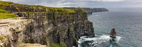
Enjoy the fantastic scenery on a walk in Ireland’s ‘Premier County’, with mountain hikes, riverside paths and lake views all on offer in Co Tipperary.
Bordering eight counties, including Offaly and Galway to the north and Cork and Waterford in the south, Tipperary is home to the famous Rock of Cashel and Mitchelstown Cave, and also shares Lough Derg with Co Clare. Tipperary is also home to some amazing mountains like the Galtees, The Devil’s Bit and Slievenamon. There are so many reasons to visit Tipperary and the beautiful walks here certainly add to the attraction. Check out some of the best walks in Tipperary below.
1. Graves of the Leinstermen Loop
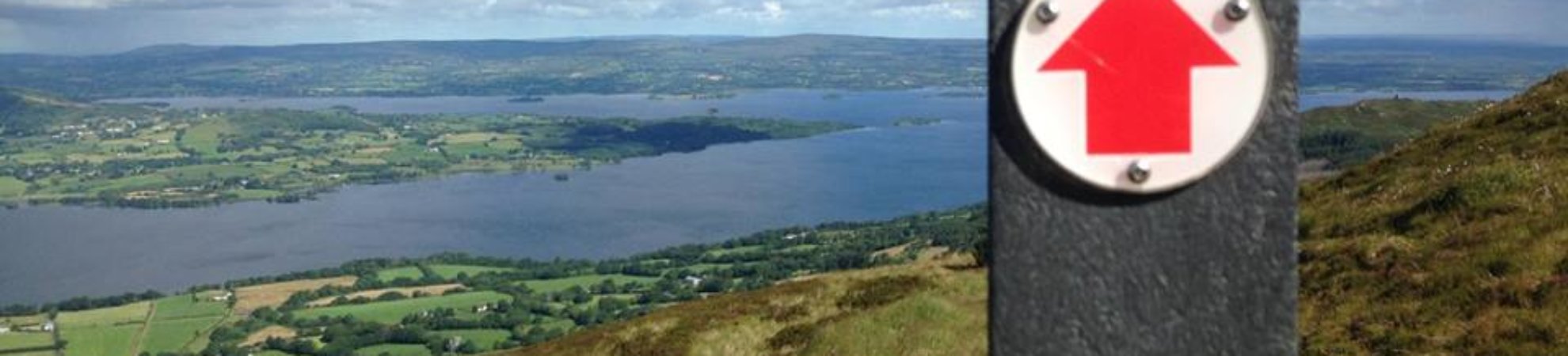
If folklore and legends interest you, then you will love the stories associated with many of the hill walks in Co Tipperary. This particular walk brings you to the top of Tountina (459m) in North Tipperary where legend has it that the men of Leinster and their king met their deaths at the hands of High King Brian Boru’s soldiers in around 1000AD. The attack was planned by Brian Boru’s wife, as their daughter was supposed to marry the King of Leinster and she did not approve. This 6km looped walk is on both minor roads and mountain trails and is ideal for those with a medium level of fitness. It should take you 2-3 hours to complete the loop. From the top of Tountina you will get fabulous views of Lough Derg and its islands, and across to Co Clare. The walk begins just between Portroe and Ballina. The Graves of the Leinstermen is be well signposted from both villages. From the main road, you will turn up a small road. Follow this for approx. 2.5km and keep left at both Y junctions.
2. Devil’s Bit Loop
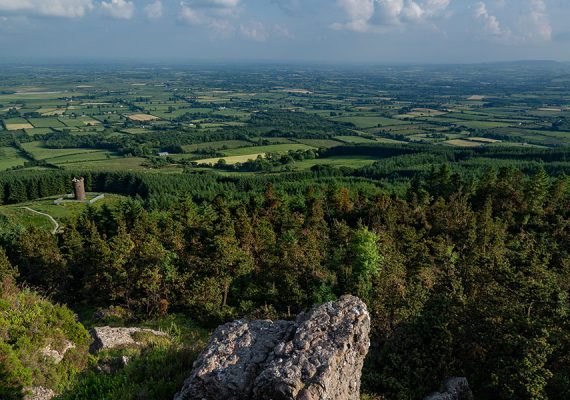
From high kings to the devil himself, folklore has it that the man with horns took a bite out of this mountain and broke his tooth while doing so. His broken tooth now stands at the Rock of Cashel. This loop walk near Templemore will take you along the side of the Devil’s Bit mountain. If you wish to reach the summit (478m), there is a path leading off the loop. From the top on a clear day, you can see all eight of the counties surrounding Tipp. This walk is on Sandy laneways, forestry tracks and hillside paths. The total length of the loop, not including the climb to the summit, is 5km and should take you about two hours. There are some steep inclines on this walk so a moderate level of fitness is required. The route starts about 3km from Templemore on the road to Nenagh. The turn off the main road is signposted for Devil’s Bit.
3. Slieve Feilim Way
The Slieve Feilim Way is a 43km linear route from Murroe in Limerick to Silvermines in Tipperary. The route will bring you around Slieve Feilim (422m), Keeper Hill (694m) and the Silvermine Mountains (475m). The route is marked with yellow arrows on a black background. To complete the whole route would take about two days but it can be done in sections like Murroe to Toreenbrien, Toreenbrien to Toor, Toor to Mulkear and Mulkear to Silvermines. The paths are a mix of quiet roads, forestry tracks and field paths. Expect spectacular views along the way, especially on the northern part of the walk. Public transport and accommodation along the route are limited so make plans for these before you start.
4. Dun Ui Faolain Loop
This loop walk is in Glenbawn Wood, a Coillte-owned forest outside Clonmel. It used to be the fort of the Faolain chiefs of the Deise, hence the name. This is the longest of the three loops in the forest at 5km. The walk starts in the Glenbawn Wood car park and from there you follow the purple arrows to stay on track. Over 1km of this loop is right by the riverbank of the River Suir. The paths are woodland trails or riverside paths. This walk is relatively flat with a maximum ascent of 70m. This hike should take less than two hours and is of moderate difficulty.
5. Ballinacourty Loop
The Glen of Aherlow is a lush valley where the River Aherlow runs between the Galtee Mountains and the wooded ridge of Slievenamuck. This loop follows woodland trails and forestry tracks through Aherlow Nature Park and Ballinacourty Woods. This 6km trail offers beautiful views of the Galtee Mountains. Be prepared for several ascents along the way with a total ascent of 240m. This route is marked with purple arrows and overlaps with the long-distance Ballyhoura Way. The route should take about two hours. From Tipperary town, head towards Knockanrawley and then on to the R664 to the Christ the King statue.
6. Slí Eala Linear Walk
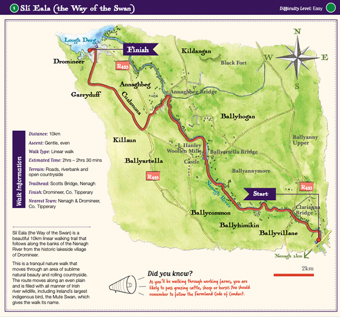
This is a 10km linear walk which will take you from the historic village of Dromineer to Scotts Bridge along the Nenagh River. You can either start this walk in the centre of Dromineer village or at Scotts Bridge, 2.5km from Nenagh town centre. Along this route, you can expect to see all kinds of wildlife including Ireland’s largest indigenous bird, the mute swan. You will also pass through working farms so you should also see cows, horses and sheep, which is nice if you have kids in tow. While this walk is long it is relatively easy as there is no ascent.
7. Lough Derg Way
Another long route is the Lough Derg Way stretching 69km from Limerick City to Dromineer Co Tipperary. This route will bring you along the River Shannon, the old Shannon navigational canal and the eastern shores of Lough Derg. Expect to see some of the finest scenery of Lough Derg. The terrain is a mix of riverbank path, canal bank, forest track, open countryside, old roadway and minor road. There are five trailheads along the route allowing you to break the walk into sections and do parts of it. They are Limerick city; Clonlara, Co Clare; Killaloe, Co. Clare and Ballina, Co. Tipperary, Garrykennedy, Co. Tipperary and Dromineer, Co. Tipperary. This walk is moderate to difficult and requires a decent level of fitness to do the whole thing as it would take two to three days to complete.
8. Loch Dhoire Bhile Loop
This is a short hike to suit all levels of fitness. The 3km walk was developed as part of a heritage, angling and conservation project undertaken by the local community in recent years. The land previously belonged to Bord na Móna and was used for milled peat production. Now it is home to a lake, two wetland areas and a wildlife sanctuary, as well as this loop walk. The route is perfect for kids as they can look out for all the wildlife that make this park their home. It is situated just under the Slieveardagh Hills. Loch Dhoire Bhile is about 3.5km outside New Birmingham village.
9. Keeper Hill Hike
View this post on Instagram
Situated in North Tipperary in the Slieve Feilim mountain range, Keeper Hill is the highest peak (694m) in the Shannon region. The mountain is surrounded by 3,300 hectares of forest. The Keepers Hill hike is a 16.4km out-and-back hike starting at Doonane trailhead, Co Tipperary. Follow the purple and red arrows along the way. If you want to go to the top follow the red arrows. There will be some steep inclines and the total elevation on this hike is 809m. You’ll need to be moderately fit to complete this climb.
10. Galtymore and Galtybeg
One of the highest mountains in Ireland, and the highest inland mountain, Galtymore (919m) is part of the Galtee Mountains. It sits on the border of Tipperary and Limerick and is the highest peak in both counties. This walk begins in the Galtymore car park. If coming from Mitchelstown, Co Limerick, follow the M8 towards Cahir. Pass through Kilbeheny and, shortly after leaving Skeheenaranky, take a turn on your left which should be signposted for Galtymore. Continue on this road until it eventually becomes a car park. The walk starts here. Follow the road from the car park and go through a gate in a northerly direction. You then go through a second gate along Black Road. The path will take you around Knockeenatoung but not to the top. From here you will be aiming for the point in between Galtymore and Galtybeg and the path will eventually bring you to the peak of Galtymore. From here it is easy to continue to Galtybeg, which is the more sheltered peak. From Galtybeg you can join back up with your original path and get back to the car park the same way you came. This climb is quite steep and will take about four hours. It’s advisable to bring a map and compass and know how to use them!
Check out our Hard as Nails podcast:
Like this? Check these out:


I have noticed you don’t monetize outsider.ie,
don’t waste your traffic, you can earn additional
cash every month with new monetization method.
This is the best adsense alternative for any type of website (they approve all websites), for more
details simply search in gooogle: murgrabia’s tools