If the headline grabbed your attention, you most likely are very familiar with the demise of the beloved Viewranger app and its merge with OutdoorActive. Since the merge, many walkers and hikers (particularly in Ireland and the UK) are quite unhappy with the change.
But, a newcomer in the hiking/navigation app market – HiiKER – is answering a lot of the questions left in the wake of the fall of Viewranger. And as an added b0nus, it’s Irish!
HiiKER originally started in the long-distance hiking market. The app was originally developed to assist those that were planning and hiking on trails for multiple days/weeks/months. The needs of these folk were a little more specific compared to the needs of a short distance/day hiker or a hill walker. These needs were (until earlier this year) quite well catered for by Viewranger.
In June of this year, HiiKER launched a major update to their app which has attracted the attention of many of the die-hard Viewranger fans. While the update is still in its infancy, there is a lot to compare. So let’s dive in!
Trail Discovery
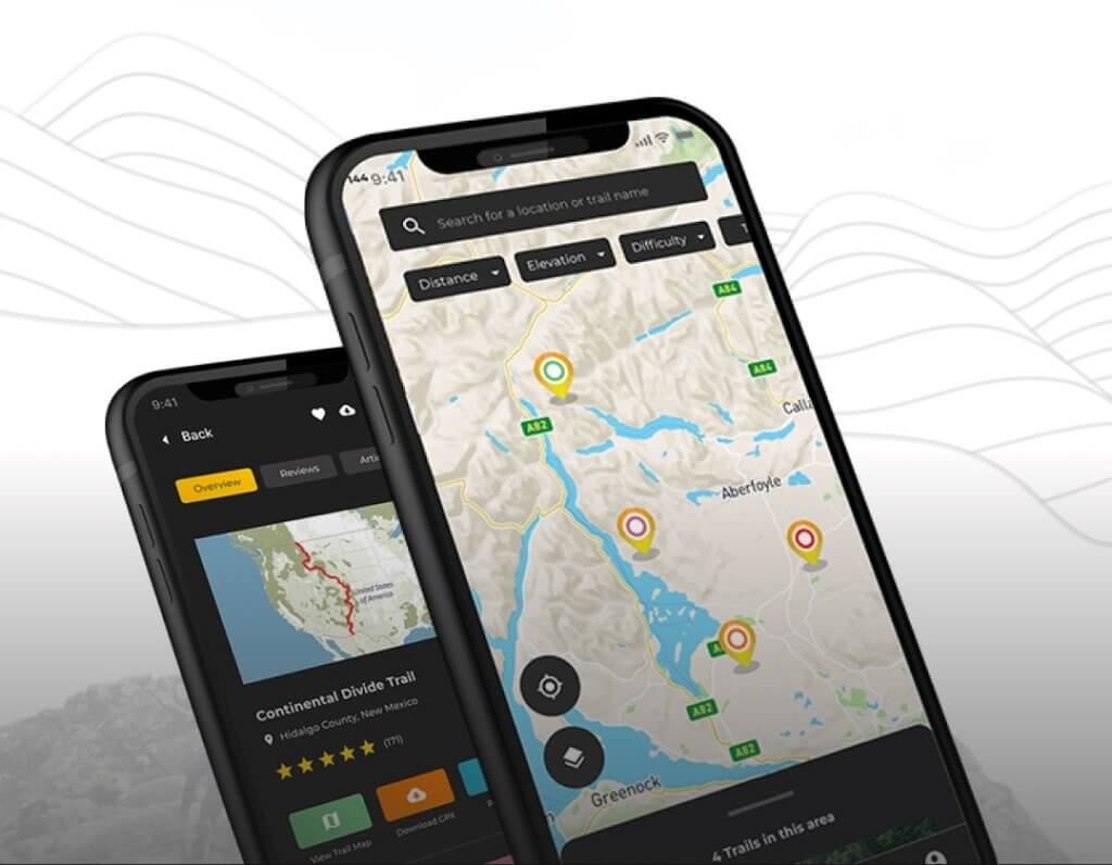
One of the many great uses for Viewranger was to find trails suited to a hiker’s ability and time restrictions. Their library of thousands of hikes, made it easy for someone to find the right trail for them and head out with confidence.
HiiKER has this same functionality and has a huge database of hiking trails from all over the world. What’s more impressive is that these trails are all verified and come from trusted sources. That means that the data was not uploaded by anyone, but they were sourced from trail organisations, trail groups and were checked by a team of trail inspectors.
You can choose from over 13,000 trails on HiiKER, add them to your bucket list and share them with your friends. Just be careful not to get ahead of yourself! There are only so many you can do.
Route planning
Viewranger was renowned for its route planner. Hikers could place waypoints across their screen and the app would use auto-snap functionality to create a custom route for users, which they could then view for navigation.
Since the update, this is now a feature on HiiKER. Users can now plot their waypoints on the map to create their custom routes. The intuitive auto-snap functionality links the waypoints using Open street maps (OSM), but users have the ability to disable the auto-snap function and draw the map manually.
Premium Maps
Another great addition to Viewranger, was the library of premium maps that were available on the app. Users could choose map layers such as OSi, EastWest mapping, OS maps and Harvey maps to enhance the functionality of the app. While some of these moved over to OutdoorActive, not all of them did and the functionality in how to access them has been a point of contention.
For Irish users, they’ll be happy to hear that EastWest maps are now available on HiiKER exclusively. As well as that, the growing library of premium maps also already includes OS maps, OSi and Harvey maps. These premium maps are really useful across the other features of the app – especially the route planner.
Custom Settings
For the more experienced walkers, you might be familiar with the custom settings Viewranger had, which enabled you to alter the calculation of hike times, manipulate the zoom of maps and to enable the local Grid references.
Yep, you guessed it, HiiKER also has this functionality. If you are used to using the Irish Grid reference system, HiiKER has made it easy to set this up. This is particularly useful for situations where Mountain rescue needs to be contacted and you need the grid references for your location.
Activity Tracker
Of course, if you’re one for statistics or simply want to share your tracked hikes with your friends, you likely used Viewranger’s activity tracker. The update to the HiiKER app also included a similar activity tracker which utilises much of the other useful functionality throughout the app.
There are some issues with power management on some devices which pause many user’s hikes, but subsequently HiiKER has provided instructions on how to improve this experience.
New Features
HiiKER also has some additional features which Viewranger never got the chance to include.
Measurement tool: the ability to measure specific distances on a trail. This proves very useful when on trail and needing to know how long it will take to get to a peak/village etc.
Points of interest/Waypoints: points on the map which provide information helpful to a hikers planning of a trip. Includes; water sources, towns, accommodation, public transport etc.
Suggest waypoints: users can provide information on waypoints that are not currently on the app. This data helps users to see recent additions to trails. Or if certian waypoints are no longer valid.
Conclusion
So is the new HiiKER app a good replacement for the much loved Viewranger? Does it do everything that its predecessor did?
While there are still some improvements that need to be made, many of the questions left by Viewranger have been answered. Mainly to the UI and cloud syncronisation.
With many other “catch-all” outdoor activity apps on the market, the needs of hikers are never paramount. HiiKER is an app that is built exclusively for the needs of hikers and hill walkers. That means that the requirements of hikers will always be a top priority.
Try it for yourself
There’s no better way to find out than by trying it out for yourself. The app is free to download and most of the functionality is also free. Head over to the Appstore or playstore to check it out for yourself.