Kerry has so many great hikes on offer that it can be difficult to narrow down the search. Hikes vary from climbing the country’s highest mountain, Carrauntoohil, to stunning coastal family walks. Here are five of our favourite.
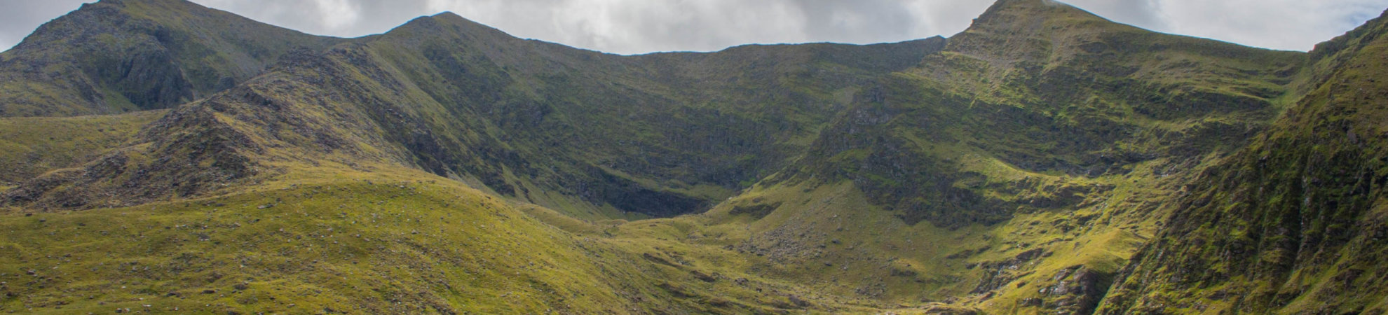
The Kingdom is littered with our tallest mountains and best beaches, lakes, forests, rugged coastlines, cliffs, stunning ridges and incredible peaks to explore for hikers of all abilities. Home to Ireland’s highest mountain range, the Macgillycuddy Reeks, it offers some of the country’s most picturesque and challenging climbs. Up to 25,000 hill walkers go adventuring through their vales and hills every year – it’s a brilliant playground for outsiders!
1. Carrauntoohil – Devil’s Ladder route
Carrauntoohil Ordnance Survey Maps: 78
Carrauntoohil Height: 1039m
Duration: 12 km return, 4-6 hours return
Good for: Experienced hikers who want to tackle Ireland’s highest peak, or intermediate hill walkers ready to step up.
The most popular route up Carrauntoohil is the Devil’s Ladder. It’s the most direct way up, yet it is still a pretty strenuous walk that will take you between four and six hours. The track is easy to see and follow. Most people start this route at Cronin’s Yard and follow the well-worn path up through Hag’s Glen, crossing the lovely Gaddagh River. Hag’s Glen is a wide open valley that’s really beautiful with a lake on either side of the trail, Lough Gouragh and Callee. You’ll hike through a boggy section before reaching the base of the Devil’s Ladder.
Hag’s Glen is a wide open valley that’s really beautiful with a lake on either side of the trail, Lough Gouragh and Callee. You’ll hike through a boggy section before reaching the base of the Devil’s Ladder.
The Devil’s Ladder is quite a tough part of the climb. It’s a steep gully with loose scree that can get quite crowded so it’s best to leave some room between you and others to avoid falling stones. Once you’ve scaled the ladder, the trail veers right to take you up the long climb to the summit.
After all your hard work, the summit is breathtaking. You’ll be surrounded by a rich panorama of mountain peaks and dramatic ridges in nearly every direction. There are also numerous lakes to be spotted, the Wild Atlantic Way in the distance, and to the north east, you should see the rich farmland of Co Kerry.
2. North Kerry Way
North Kerry Way Ordnance Survey Maps: 63 and 71
North Kerry Way Height: Maulin Mountain (218m)
Duration: 48km or 3 days, or take it in shorter stages. Has been done in 16 hours on one day if you’re really keen
Good for: A moderate hike that can be as long or as short as you make it with stunning coastal views around the Wild Atlantic Way in Kerry
The 48km North Kerry Way is a beautiful coastal walking route that starts in Tralee, Co Kerry, and can take you as far as Ballyheigue and around the Kerry Head Peninsula.
It’s not as popular as the nearby Dingle Way or Kerry Way but it’s views and coastal features are just as scenic. You’ll enjoy beautiful sandy beach walks, the deep blue Tralee Bay and coastal paths with mountains and fields dipping down to the rocky shoreline. The area, including the Tralee Valley, is also steeped in history, with ancient sites, forts, castles, and churches visible along the way.
Start in Tralee itself and walk out towards Blennerville along a trail that is also the Dingle Way. It takes you along the historic canal walk of the old Tralee Ship Canal. Also check out the swing bridge at Blennerville and the Blennerville Windmill, which is the country’s oldest working windmill and can be found at the point where the North Kerry and Dingle Ways part company.
From there, the North Kerry Way heads north towards the coast along a sea wall to Tralee Bay. The walk will take you past the vast and remote Banna Strand, a beautiful, long, sandy beach with Blue Flag status. From here, you’ll see views of the mountains on the Dingle peninsula, Maulin Mountain to the northwest and Mucklamore Rock out in the Atlantic Ocean. There are kilometres of protected sand dunes, which are home to rare plant and animal wildlife. It’s also pretty popular as a swimming and surfing beach.
Further north of Banna Strand is the scenic, mountainous Kerry Head Peninsula that stretches out into the Atlantic Ocean, and also Ballyheigue’s Blue Flag beach. The Kerry Head loop track (18km) circles the headland and can be hiked or cycled. This can be a lovely shorter family walk.
The peninsula features the ancient Cahercarbery Forts, which are thought to date back more than 2,000 years. You can climb the peak of Maulin Mountain on a 5/6km round trip up a well-established track. From the top on a clear day, you’ll have beautiful views out into the wild Atlantic Ocean, up to Loop Head in the north, as far as the Shannon Estuary, south to Tralee Bay, Mount Brandon and the Slieve Mish Mountains.
Hiking Carrauntoohil: everything you need to know
3. Lough Googh Loop Walk
Lough Googh Ordnance Survey Maps: 78
Lough Googh Height: Cnoc na Peiste (988m)
Duration: 10 km loop, 5 hours
Good for: Most hikers who want a moderate hike that’s not as challenging as Carrauntoohil. Be sure you’re ok with heights as there are narrow ridge sections.
This is a moderate to strenuous hike in the eastern Macgillycuddy Reeks taking in part of the world-renowned Killarney National Park and includes waterfalls, lakes, ridges and mountain views.
The walk starts and finishes near Killarney. The early part of the hike will take you past the beautiful Lough Googh and includes a number of waterfalls to spot along the way. The walk then starts to climb the slopes of Cnoc na Peiste, which is the fourth highest summit in Ireland. The mountain is the highest point along a ridge that connects Carrauntoohil and the Purple Mountain that features the beautiful mountain pass, the Gap of Dunloe.
Once you’ve reached the top, you head east along a narrow and fairly exposed ridge to pass two more of the Reek’s eastern mountains, the Big Gun and Cruach Mor. You’ll then drop down into the scenic Derrycarna River Valley to take you back to your starting point for a well-deserved rest.
4. Mount Brandon
Mount Brandon Ordnance Survey Maps: 70
Mount Brandon Height: 952m
Duration: 9/10km or 4-5 hours
Good for: Moderate hike for beginner/intermediate hikers. The trail is well-marked so no need for navigation skills in good weather.
Mount Brandon is the ninth highest mountain in Ireland. It’s the location of the peak to the north of the Dingle Peninsula that makes for epic views of the west coast and a superb hiking experience. It’s one of the best mountain walks along the Wild Atlantic Way and is an ancient route for pilgrims dating back to prehistoric times.
The mountain is named after ‘St Brendan the navigator’ who was born in Fenit near Tralee in 484AD. It’s believed he was the first European to discover the US around a thousand years before Columbus. There is a series of small white crosses lining the path to the peak, which is also topped with a large metal cross.
Park in the car park near the Faha Grotto. Follow the trail and you’ll pass the Marian Grotto and a second monument that people used to visit seeking cures for ill health. You’ll then start up a gradual incline up to the Faha Ridge and carry on below the ridge on the lower trail into a beautiful glacial valley. This valley features stunning glacial formations like lakes, waterfalls and impressive sheer cliff faces. On a good day, you should be able to see at least two nearby lakes, Paternoster and Coumacknock Loughs.
You’ll then climb a rocky path up the cliff in front of you, zig zagging up to the col towards the summit. From here, enjoy the majestic views of the rugged Dingle Peninsula and Atlantic coastline, the Macgillycuddy Reeks and Carrauntoohil to the southeast, the Blasket Islands off the Kerry coast and even the Aran Islands in the north in the distance.
Hiking gear: what you need to get you started
5. Ireland’s three highest mountains in one day – Coomloughra Horseshoe Loop Walk
Coomloughra Ordnance Survey Maps: 78
Coomloughra Height: Carrauntoohil (1039m), Caher Mountain (1001m) and Beenkeeragh Mountain (1010m)
Duration: 12 km return, 7 hours return
Good for: Experienced walkers keen to tackle one of Ireland’s most scenic ridge walks, must have a head for heights!
This is a really spectacular ridge walk to approach the summit of Carrauntoohil from the south western side of the mountain. It traverses the dramatic ridge above Coomloughra Lough and Lough Eighter and also takes you to the top of the Caher Mountain and Beenkeeragh Mountain.
It’s best attempted by experienced hikers with a good level of fitness, or with a guide or group. It is very exposed due to the amount of time you’ll be hiking on the top of steep/narrow ridges, so checking the weather is vital.
To start this walk, you need to park in the Hydro Road car park and walk along the steep, concrete Hydro Road for a time, which gives you a heart pumping start to your adventure. The trail continues up the steep lower section of Skregmore and then flattens out as you turn right towards Lough Eighter. From the lake, you’ll turn right again towards the slopes of Caher Mountain. As you climb up towards Caher, the incline gets steeper on your left until you’re basically traversing a cliff edge.
The trail will take you along the really scenic Caher Ridge Path with great views and takes in the summit of the Caher Mountain before you descend a little to the col on the way to Carrauntoohil. The final push up to the summit is a safer, more manageable slope. Some walkers simply retrace their steps and go back down at this point, but keep pushing on to take in another of the country’s highest mountains.
The Coomloughra Horse Shoe route continues over the top of Carrauntoohil and on to the Beenkeeragh Ridge and Mountain. Be warned that the Beenkeeragh ridge is very exposed and like a knife-edge in places with serious drops, so experience is needed and extreme care is advised.
Once you summit Beenkeeragh, you’ve just climbed three of Ireland’s highest mountains in one day – well done! Given the Macgillycuddy’s closeness to the Atlantic Ocean, the weather can be very changeable very fast, so you should be prepared for wet, wind, cold and more if you’re heading into the hills there.
Check out our Hard as Nails podcast:
Like this? We also think you’ll love these: